
Readers may well remember that some time ago I published a ‘One Way to do Venice…’
…which basically charted a walking route from the Venice Cruise Terminal to St Mark’s Square.
Having visited Venice on numerous occasions it occurred to my wife and me that there must be more to see of Venice than simply following that well beaten and signposted route.
With the idea of exploring the area north of the Grand Canal this account, of our journey through the Venice district of Cannaregio, may prove useful to those who have also out-done the main tourist route.
For the purpose of a starting reference point I have chosen the Santa Lucia Railway Station and the Scalzi Bridge, both of which featured, and can be found, in the previous ‘One Way to do Venice‘.

That’s the Santa Lucia Railway Station marked A1 on the above map.
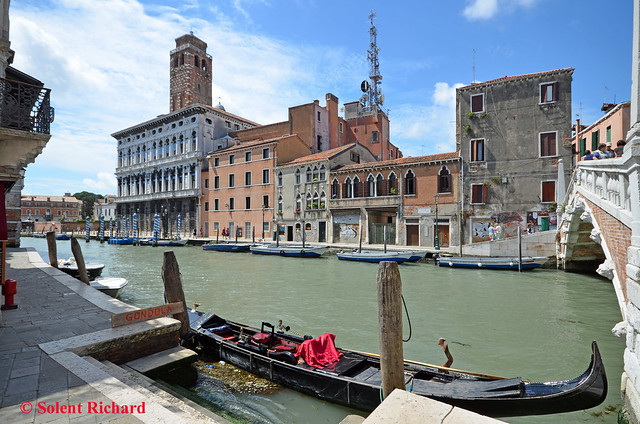
Leave the front of the station and walk in the direction of the Scalzi Bridge, though this time do not cross. Instead, follow the ‘Ria Terra Lista di Spagna’ as far as Campo San Gerimia where the first of many churches and palaces on this walk will be observed…

That is Chiesa (Church) di San Geremia on the right with Palazzo Labia-Salone on the left. The baroque palace dates back to the 17th–18th century and is one of the last great palaces in Venice. Though little known outside of Italy it is most notable for its remarkable frescoed ballroom.
Continuing along Terra Lista di Spagna there is a bridge over the Cannaregio Canal that offers this view along Rio Terra san Leonardo…

…a bustling street with market stalls, shops, cafes and restaurants.
However, why not look over one’s right shoulder back across the Cannaregio Canal – there’s a better view of Palazzo Labia-Salone…
We continued along the San Leonardo as far as Calle Farnese, a side street to the left. A short distance along this street brought us to…

…effectively the rear entrance to Campo di Ghetto Nouvo (A3 on the first map)
Well hidden behind the nondescript facade, Campo di Ghetto Nouvo was effectively a city within a city which boasted five synagogues. Instituted in 1516, this was the world’s first Jewish Ghetto though restrictions on Jewish rights and residences in Venice existed before that date.
It is now a secluded area full of charm and not too far from the most frequented touristic routes with a museum, the best preserved medieval synagogues in Europe: a unique testimony to Jewish history….

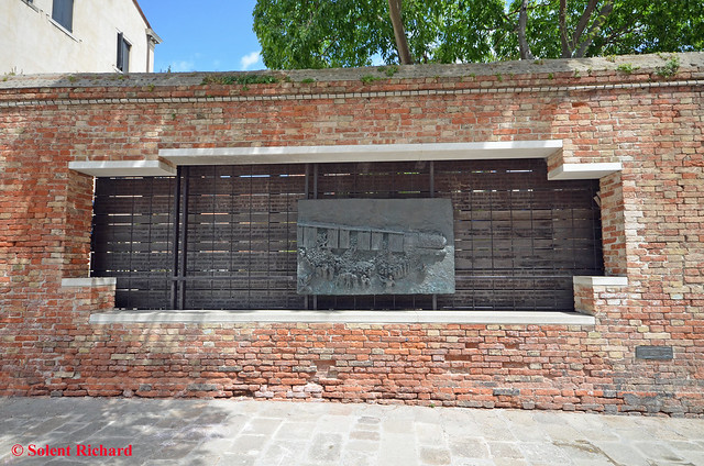
The memorial for the Holocaust victims. Jews were gathered in this area to be exported to concentration camps.

*****

*****
Entrance to the Synagogue Museum from the square…

Campo di Ghetto Nouvo, or the Venetian Ghetto, was the area of Venice in which Jews were compelled to live under the old Venetian Republic. From the outside there is little visible evidence of any difference between the Ghetto and the rest of Venice bar from he very high and narrow houses which had to be built due to lack of space in the17th century.
Instituted in 1516, this was the world’s first Jewish Ghetto though political restrictions on Jewish rights and residences existed before that date. Today only a few Jews live here.
Following our visit to the ghetto we crossed the Rio Della Misericordia Canal: easily accessed from the Ghetto square to the right hand side of Kosher House Giardino Dei Melograni which overlooks both the Ghetto and the canal…

*****

Following the route on the map above we headed for the next canal that runs parallel to the Rio Della Misericordia , the Rio Della Sensa…

….which we then followed as far as the small square named ‘Campo Dei Mori, (A4 on the first map)

This square has its roots in the silk and spice trade. Set into the wall of one side of the square are three stone figures, those of the Mastelli brothers. These brothers , initially from Morea, set up business in 1112. Legend has it that the three brothers were turned to stone on account of their greed…

At this point we were not far from our next target destination, the church whose tower can be seen left centre on the previous but one photograph.
However, we spotted the restaurant on the corner of the square, the Osteria L’Orto dei Mori . It proved a rather unique restaurant with a relaxed local atmosphere, and we enjoyed an excellent pasta and artichoke salad lunch
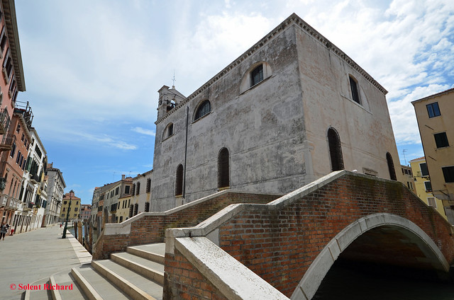
Suitably fed and watered it was but a short walk from the ‘Campo Dei Mori to the church of Madonna dell’Orto (A5 on the first map)…

It is one of the finest Gothic Churches in Venice, has a richly decorated facade and inside lies a wealth of works by Tintoretto, the Italian painter and a notable exponent of the Renaissance School.
Circumnavigating the church to the waterfront we enjoyed a view of the island of San Michele (A6 on the first map)

The island is home of the first Renaissance church in Venice plus a monastery. Its place in history, however, came in 1807 when, under French occupation, it was decreed that burial on the mainland (or on the main Venetian islands) was unsanitary and the island became Venice’s main cemetery. Bodies were carried to the island on special funeral gondolas.
Retracing our footsteps back to the Church of the Madonna we then continued along the aptly named Rio della Madonna till we arrived at the Pont (bridge) Sacca della Misericordia (A7 on the first map)…
The Sacca della Misericordia is in fact a large man made basin opening out into the lagoon and offers views again of the island of San Michele and also the island of Murano plus a view back along the Rio Della Madonna and its Fondamenta Gaspari Contarini…

A short distance from the Sacca della Misericordia we came across the Scuola Grande della Misericordia (A8 on the first map)…

It has been a seat of education since it was formed the September 8, 1261 though it later became more famous as a gymnastics venue.
We now followed the canal in the direction as seen above to the first bridge which crossed the canal near the church of San Marziale…
…and continued in roughly a straight line till we reached the considerably more spectacular Chiesa di Santa Fosca…(A9 on the first map)

The church faces the Campo (square) of Santa Fosca and is adjacent the Strada Nova. On this campo stands the monument to Paolo Sarpi.
From here on we really return to the Venice of the tourist, beginning with a walk along almost the length of the Strada Nouva: a busy, buzzy and bustling endless collection of shops, cafes, restaurants and bars and market stalls, at the end of which we discovered the Chiesa dei Santi Apostoli di Cristo (English: Church of the Holy Apostles of Christ) and more commonly called San Apostoli, (A10 on the first map)…

A Roman catholic church dating back to the 7th-century it is one of the oldest churches in the city and has undergone numerous changes since its foundation. The present building is the result of a major reconstruction project which was undertaken in 1575. The chapel is the burial place of several members of the powerful Cornaro family, including Catherine Cornaro, Queen of Cyprus. The church houses several works of art including pieces by Giambattista Tiepolo and Paolo Veronese.
At this point we change to our second street map in order get us to Piazza San Marco and some other equally interesting places on the way…

The route may look daunting but it reality it is going to be simple.
From San Apostoli we will simply follow the signposts to Rialto, the route is well signposted as remember, we are now back in Tourist Venice.
Having crossed the Canal Fontego del Tedeschi and not too many yards from the Rialto Bridge we came across this amazing bar, The Bacaro Jazz Bar (B1 on the second map)…

This really looked a fun bar and on discovering that ‘happy hour’ commenced less than 2 hours later we decided to call in on the way back.
The baccarat Jazz Bar is less than 5 minutes walk from the Rialto Bridge…
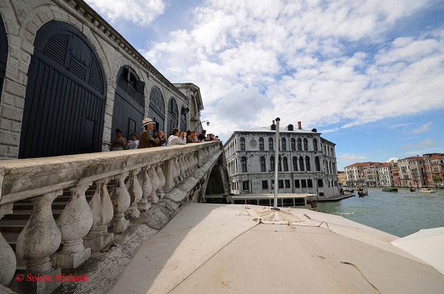
For those who may not have seen the Rialto Bridge before I would suggest crossing it first for the better views are the other side…

…but do take a close look at the Palazzo dei Camerlenghi, from the approach side…

The palace was built in 1528 and was the seat of several financial magistrates, including the Camerlenghi from whom it takes its name, the Consuls of the Traders and the Supra-Consuls of the Traders. Due to this function, the lower floor was used as a jail for the insolvents. It is currently the regional seat of the Italian Auditor general.
Heading away from Rialto we followed the general direction of the signs to Piazza San Marco (St. Marks Square) but deviating slightly to cross Campo Manin.
The Palazzo Contarini del Bovolo (also called Palazzo Contarini Minelli dal Bovolo) is a small palace, best known for the external spiral staircase, with a plethora of arches, known as the Scala Contarini del Bovolo (of the snail).
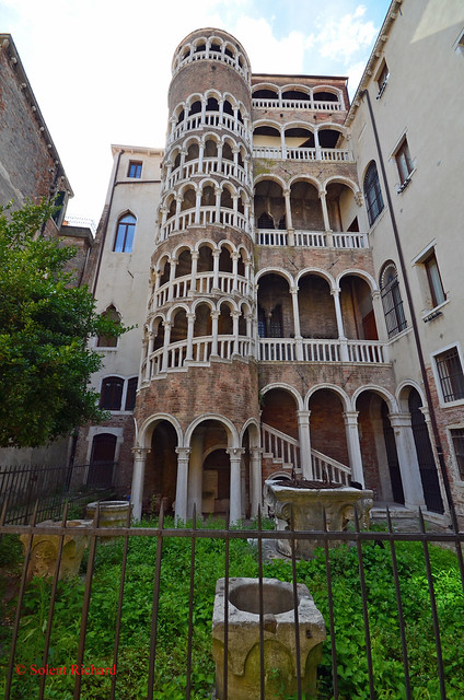
The palace is located in a less-traveled side-street near the Campo Manin, near the Rialto.
The staircase leads to an arcade, providing a charming panoramic view over some of the roof-tops of the city.
The final church that we viewed was The Chiesa di San Moisè (B6 on the 2nd map) …

Built initially in the 8th century it is, as the name suggests, dedicated to Moses. Its elaborate Baroque facade is covered in carvings.
Retracing our steps for no more than 5 minutes we entered Piazza San Marco, (or, as known in English, St Mark’s Square)…

It is the principal public square of Venice, where it is generally known just as ‘la Piazza’. All other urban spaces in the city are called “campi” (fields). The Piazzetta (the ‘little Piazza’) is an extension of the Piazza which runs from the tall Campanile towards the lagoon.
Having once again soaked-up the atmosphere in and around St Mark’s Square it was time to consider our walk back. One may recall that we had a tentative call in mind on the way back, to the Bacaro Jazz Bar.
Our return route plan was simple. We would take the route we took in my previous review of Venice…
…and simply follow the more than adequate yellow signage…

…with the exception of a short diversion at the Rialto Bridge in time for ‘Happy Hour’ at the Bacaro Jazz Bar.
What a fun place. Bellinis and Margueritas were the order of the day…

…while we admired the bar’s uplifting decor…

…and we both generally had a good time…

…before trekking back to Piazzale Roma.
I hope this account of our day in Venice ‘off the beaten track’ has proved interesting and maybe inspirational. It’s certainly different and there are so many other quirky parts of Venice to be seen, away from the general tourist spots. Here are one or two…
Hidden gems

Where only locals eat
Back-street Venice

Romantic Venice

…and of course, the maybe not so romantic

If you have enjoyed this review of an alternative Venice and would like to be amongst the first to hear of new reviews ( which will soon include Oporto and Cartagena, as well as Tahiti) why not join the many other followers by clicking on the ‘Follow’ link on the front page. You will be alerted by email immediately a new post appears.

This list is a mix of some of my favorite off-the-beaten track landmarks and a few handpicked, must-see places. Search for these spots, and other secrets tucked around the city, to discover your own unique Venice. The best way to experience Venice is to pick a direction and wander. Getting “lost” allows you to stumble upon the city’s many secrets.